We take advantage of a sunny autumn day to undertake a hike from passo di Lavazè to the peak of the Pala di Santa from where we will enjoy an all-round view
Image gallery: Passo di Lavazè and Pala di Santa circular hike


With the sun in our face we drive towards Passo di Lavazè situated in the municipality of Varena. We park our car near the Bucaneve hotel at the crossroads where the road to passo Oclini starts. Initially, we follow the large forest road non. 574 towards the Pala di Santa, a 2,488 m high mountain in the Val di Fiemme Alps.
The path begins to ascend and a wonderful view of the pass, which is still in the shadow, opens up. After an easy 1-hour walk we arrive at the small Le Tombole pass at 2,000 m a.s.l. At the crossroads we continue along path no. 574 (Pala di Santa). Now the ascent through the forest gets steeper and more challenging. At a certain point we recognise the summit cross, our final destination, in the distance.
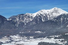
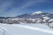
The stony path ascends in switchbacks and after about 90 minutes of walking we finally reach the peak where we admire the fantastic panorama. The Antelao, Pelmo, and Civetta peaks, the Pale di San Martino, the Lagorai and Brenta groups, as well as the Ortles, and the Latemar and Catinaccio groups with the Sciliar in South Tyrol extend in front of us.
For the descent we follow the tracks at the right of the summit cross to the lift facilities until we arrive at a small fork without any signposts to our left. We descend along a slope which is transformed into a ski slope in winter until we spot the signposts of the slightly hilly path no. 9 that takes us back to the passo di Lavazè and to the car park.
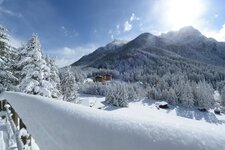
Please note: in winter the passo di Lavazè and the passo Oclini turn into a popular skiing area which also features a network of 80 km of cross-country ski tracks that extend to the neighbouring province of Bolzano where the famous Madonna di Pietralba Sanctuary can be found.
Experienced in: October 2021
Authors: Elena & Luca
Last update in: 2025
-
- Starting point:
- parking space at the Bucaneve inn (1,784 m a.s.l.)
-
- Overall time:
- 04:30 h
-
- Total route length:
- 12,5 km
-
- Altitude:
- from 1.784 m to 2.488 m
-
- Altitude difference (uphill | downhill):
- +757 m | -757 m
-
- Signposts:
- 574 (Pala di Santa), 9
-
- Destination:
- summit of Mt. Pala di Santa (2,488 m a.s.l.)
-
- Resting points:
- Bucaneve inn at the starting and end point
-
- Recommended time of year:
- Jan Feb Mar Apr May Jun Jul Aug Sep Oct Nov Dec
-
- Download GPX track:
- Passo di Lavazè and Pala di Santa circular hike
-
- More information:
- Be aware of possible snowfall in autumn! The overall time shown above refers to the walking time only, not including breaks.
If you want to undertake this hike, we recommend you to check the weather and trail conditions in advance and on site before setting out.


ThomasMonsorno-04280.jpg)
.jpg)