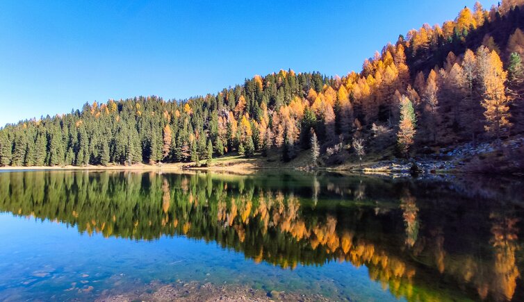
The Lago di Cece in the Val di Fiemme, a mountain lake at 1,879 m a.s.l., delights visitors with relaxing moments
Image gallery: Autumn hike to Lake Cece


We drive to Predazzo, a quite large village and famous tourist destination also known as "Pardàc". The village is delimited by the Lagorai group in the south and the Latemar group in the north-east and therefore a perfect starting point for several outdoor activities, including hikes, in the surrounding nature and mountains.
We follow the signposts to Malga Valmaggiore where we park our car. The path starts near the bridge of Valmaggiore which is only a few hundred metres away from the eponymous malga. The signposts to Lago di Cece are well-visible. Initially we follow the forest road.
After some hundred metres we turn right and walk continuously uphill along path no. 336. At a certain point this rather easy trail narrows. After an ascent we arrive at the small Campigolo Grande high plateau at 1,916 m a.s.l., the highest point of our autumn hike to Lago di Cece.
From here it takes us another 15 minutes to reach the wonderful mountain lake in the Lagorai Chain**, which is now embedded in a stunning, colourful natural landscape. Unfortunately, in some weeks the hiking season will come to an end - at least for this year.
For our return route we follow the signposts to "Predazzo" standing right after the wooden hut. This well-maintained path is suitable also for all-terrain baby carriages. The path gradually gets larger until the next fork (without signposts) where we turn left. At the following crossroads we take the path back to the starting point and soon we arrive at the car park.
Authors: Elena & Luca
Experienced in: October 2019
Last updated in: 2025
-
- Starting point:
- bridge at Valmaggiore (1,170 m a.s.l.), Predazzo
-
- Overall time:
- 03:30 h
-
- Total route length:
- 10,8 km
-
- Altitude:
- from 1.170 m to 1.916 m
-
- Altitude difference (uphill | downhill):
- +757 m | -746 m
-
- Signposts:
- "Lago di Cece", 336, "Predazzo"
-
- Destination:
- Lago di Cece (1,879 m a.s.l.)
-
- Resting points:
- Malga Valmaggiore (near the starting point)
-
- Recommended time of year:
- Jan Feb Mar Apr May Jun Jul Aug Sep Oct Nov Dec
-
- Download GPX track:
- Autumn hike to Lake Cece
-
- More information:
- Be aware of possible snowfall in autumn! The overall time shown above refers to the walking time only, not including breaks or stops at mountain huts.
If you want to undertake this hike, we recommend you to check the weather and trail conditions in advance and on site before setting out.