This autumn hike takes us across the provinces of Trento and Belluno near the Marmolada
Image gallery: Hike from the Malga Ciapela to the Rifugio Falier


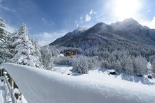
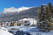
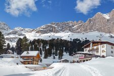
We start from Moena in the Val di Fassa and drive to the province of Belluno which we reach via Passo San Pellegrino (1,918 m a.s.l.) after an hour's trip. We travel past Alleghe and reach our starting point, the car park near Camping Malga Ciapela from which you can reach Malga Ciapela. We are in the proximity of Passo di Fedaia, a 2,057 m high saddle of the Marmolada group in the Dolomites. The Marmolada (3,343 m a.s.l.) is the highest peak of the Dolomites.
Initially, we take path no. 610 through the forest. Soon we arrive at Malga Ciapela, a mountain hut at the foot of the impressive Marmolada which also houses the valley station of the "Funivie Marmolada - Move to the top" which takes visitors to the Punta Rocca at 3,265 m a.s.l. on the Bellunese side of the Marmolada. Here stands the highest museum of Europe, the Museo Marmolada Grande Guerra dedicated to the mountain war.
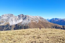
From the malga we continue to the Valle Ombretta at 1,900 m a.s.l. where the forest is replaced by meadows and pastures. The view ranges from the Dolomites behind us to the impressive southern wall of the Marmolada in front of us. This landscape accompanies us until the rifugio Falier at 2,074 m a.s.l.
As we approach the Rifugio Falier the path flattens. We arrive at the mountain hut where we stop for a break in this wonderful mountain landscape. At the end of October the mountain hut is already closed but as we already checked the opening hours of the hut beforehand, we took lunch with us. We return to the car park along the same path leading past Malga Ciapela.
Authors: Elena & Luca
Experienced in: October 2020
Last updated in: 2025
-
- Starting point:
- car park at the Malga Ciapela campground (1,454 m a.s.l.)
-
- Overall time:
- 04:00 h
-
- Total route length:
- 11,9 km
-
- Altitude:
- from 1.454 m to 2.074 m
-
- Altitude difference (uphill | downhill):
- +625 m | -635 m
-
- Signposts:
- 610
-
- Destination:
- Rifugio Falier (2,074 m a.s.l.)
-
- Resting points:
- Ombretta Hut, Falier Hut (during the summer season)
-
- Recommended time of year:
- Jan Feb Mar Apr May Jun Jul Aug Sep Oct Nov Dec
-
- Download GPX track:
- Hike from the Malga Ciapela to the Rifugio Falier
-
- More information:
- The hike is classified as easy to medium (due to the four-hour walking time and the altitude), but otherwise presents no difficulties. Be aware of possible snowfall in autumn! The overall time shown above refers to the walking time only, not including breaks.
If you want to undertake this hike, we recommend you to check the weather and trail conditions in advance and on site before setting out.