Discover the malghe of Lauregno, Brez and Castrin in one hike
Image gallery: Circular tour of the huts in the Upper Val di Non


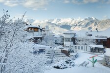
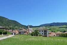
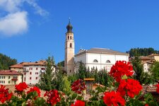
We park our car at the Hofmahdjoch car park, a pass connecting the Val d'Ultimo in South Tyrol with the Val di Non. The neighbouring villages of Lauregno and Proves belong to the Alta Val di Non. Coming from Trentino the pass is accessible from Fondo and Castelfondo. The car park at 1,663 m a.s.l. is well-visible as it lies right in front of a tunnel. We undertake this hike in May despite knowing that there could still be some snow along the path and that the mountain huts are still closed as they open in summer offering delicious food to their guests.
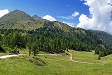
The area is quiet and immersed in a stunning natural landscape. Initially, we take path no. 26 ascending in the forest to our right. After 10 minutes we arrive at a large gravel road which we follow until Malga di Lauregno. Here we walk along path no. 26 towards Malga di Brez.
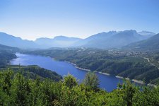
The malghe owe their name to the villages of Brez and Lauregno and passo Castrin. After a 20-minute walk we pass the first snowfields and reach path no. 114. Shortly after we arrive at another plain covered with crocuses. A slight descent separates us from Malga di Brez, the second mountain hut, where we stop for a break. Then we follow the path to our right (signposted "Stuanmandl Popi") towards cima Popi. Having passed a slight ascent we reach an upland which delights us with a stunning all-round view of the Dolomites, the Brenta Dolomites and the peaks of the Maddalene Group**.
From the cima Popi we head towards north and descend across the forest following the tracks along the frequented path until the Prieda del Gial, a place with tables and benches. We then follow the signposts towards Malga Castrin. Having passed the Monte Sous peat bog (provided with an information panel) we walk along a forest road for another hour until the hut where we stop for a break. For our return we follow the signposts to the car park which we reach after another half an hour of walking.
Tip: as an alternative you could return to the "Stuanmandl Popi" signpost and proceed along the unmarked path at 1,795 m a.s.l. which continues until a crossroads with path no. 3. Then, take the path on the right. Other popular hikes in this area are an excursion along the Sentiero di Proves to Malga Castrin and the alpine pasture walk around Proves.
Authors: Elena & Luca
Experienced in: May 2021
Last updated in: 2025
-
- Starting point:
- car park at the Passo Castrin along the road to Proves (1,663 m a.s.l.)
-
- Overall time:
- 04:00 h
-
- Total route length:
- 13,2 km
-
- Altitude:
- from 1.663 m to 1.968 m
-
- Altitude difference (uphill | downhill):
- +471 m | -471 m
-
- Signposts:
- 6, 114, 5B, 157
-
- Destination:
- Lauregno Hut, Brez Hut, Castrin Hut
-
- Resting points:
- Lauregno Hut, Brez Hut, Castrin Hut (during the summer season)
-
- Recommended time of year:
- Jan Feb Mar Apr May Jun Jul Aug Sep Oct Nov Dec
-
- Download GPX track:
- Circular tour of the huts in the Upper Val di Non
-
- More information:
- The overall time shown above refers to the walking time only, not including breaks.
If you want to undertake this hike, we recommend you to check the weather and trail conditions in advance and on site before setting out.