The Lago di Moregna, Lago delle Trote and Lago Brutto are the three marvellous mountain lakes in the Lagorai chain we are going to discover today
Image gallery: Three Lakes Hike near Predazzo


The starting point of our hike is the car park at the beginning of the road ascending to Malga Valmaggiore in Predazzo. The path SAT 339 (Malga Moregna) leads past Malga Valmaggiore before running slightly uphill. After a 15-minute walk along a forest path we turn right and cross a bridge. Then we continue along the forest path which is now getting steeper and narrower.
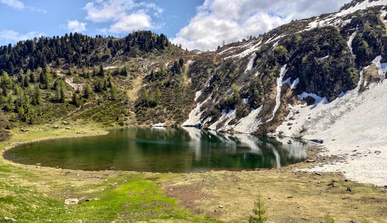
Malga Moregna and Lago Moregna are situated in a basin at the foot of Cima Moregna. We stop for a break nearby the lake before rejoining the path. At an altitude of 2,172 m a.s.l. we ascend along path no. 339 towards northwest. At the small pass we need to tackle a flat and downhill section. At the fork we follow the signpost "Lago delle Trote".
After a 5-10 minute walk we arrive at the second lake. The hiking season has just begun and we need to cross some snowfields which are bound to melt in the next weeks when summer in the Lagorai chain will also arrive at these altitudes. We admire the crystal-clear water of this wonderful lake before heading to the third and last lake of the tour, Lago Brutto.
Our path merges into trail no. 349 which descends through a very steep rocky avalanche chute until a basin where the still frozen Lago Brutto lies. We return along the path above the avalanche chute and recognise the path we took before which we follow back to the car park near Predazzo.
Please note: the numerous flattened trees in the first section between Malga Valmaggiore and Lago Moregna date from autumn 2018 when the Vaia storm devastated large areas in both South Tyrol and Trentino.
Authors: Elena & Luca
Experienced in: June 2020
Last updated in: 2025
Download:
-
- Starting point:
- car park beneath the Malga Valmaggiore (1,661 m a.s.l.)
-
- Overall time:
- 04:30 h
-
- Total route length:
- 9,9 km
-
- Altitude:
- from 1.661 m to 2.258 m
-
- Altitude difference (uphill | downhill):
- +697 m | -697 m
-
- Signposts:
- Sat 339 (Malga Moregna), 339, "Lago delle Trote", 349
-
- Destination:
- Lago di Moregna, Lago delle Trote, Lago Brutto
-
- Resting points:
- Valmaggiore Hut (starting point)
-
- Recommended time of year:
- Jan Feb Mar Apr May Jun Jul Aug Sep Oct Nov Dec
-
- Download GPX track:
- Three Lakes Hike near Predazzo
-
- More information:
- Be aware of snowfields if hiking before the recommended season (July, August, September). The highest point of the hike is at 2,258 metres and is located on the saddle described above. The overall time shown above refers to the walking time only, not including breaks.
If you want to undertake this hike, we recommend you to check the weather and trail conditions in advance and on site before setting out.